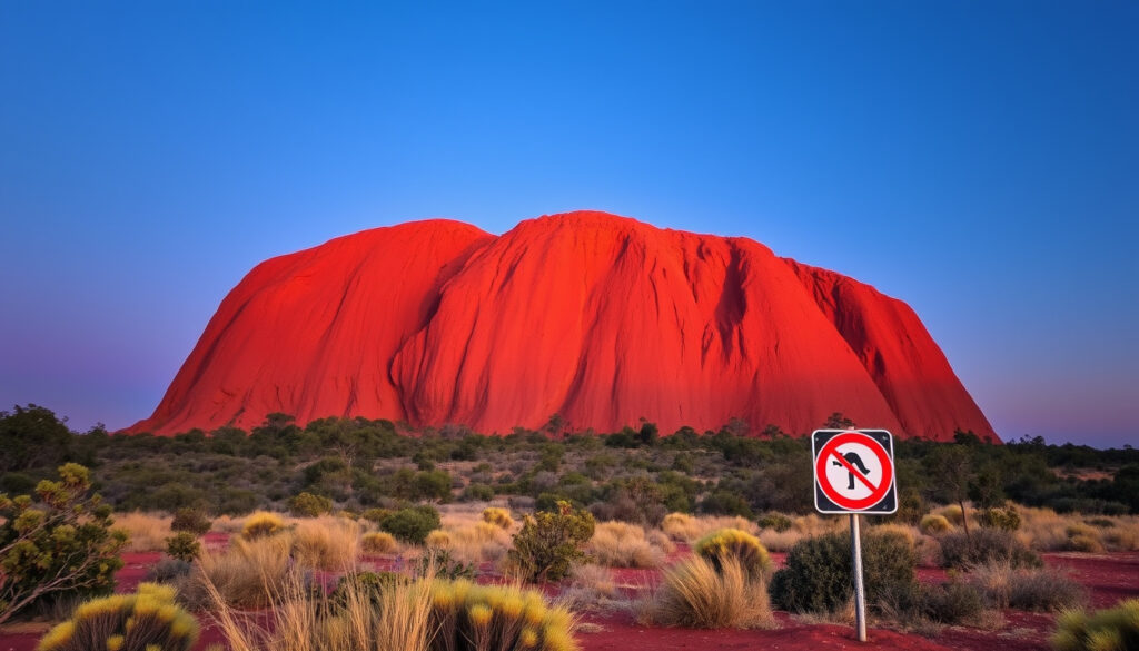
Ayers Rock (Uluru): Climbing Ban & Visitor Rules Explained
There aren’t many places in Australia that provoke as much curiosity as a massive red rock in the middle of the desert. But Uluru, once widely known as Ayers Rock, is more than a postcard — it’s a living cultural landscape. Its climbing ban, photography rules, and swimming restrictions don’t come from bureaucracy; they stem from the wishes of the Anangu people, who have cared for this land for tens of thousands of years. Understanding what you can and cannot do here means understanding a different way of seeing the world.
Height: 348 meters (1,142 ft) ·
Circumference: 9.4 km (5.8 mi) ·
Climbing ban effective: 26 October 2019 ·
Official dual name: Uluru / Ayers Rock ·
Traditional owners: Anangu people ·
Year first climbed by non-Indigenous: 1936
Quick snapshot
- Uluru is a sacred site to the Anangu (National Museum of Australia (Cultural heritage authority))
- Climbing ban effective 26 October 2019 (National Geographic (Travel and culture reporting))
- Dual name Uluru / Ayers Rock is official (National Geographic (Travel and culture reporting))
- Base Walk is 9.4 km (EBSCO Research Starters (Academic reference))
- Exact number of climbers before the ban
- Precise age of the rock art at the base
- 2017 park board vote to ban climbing; ban takes effect 26 Oct 2019 (National Geographic (Travel and culture reporting))
- Ongoing cultural management by Anangu; potential further restrictions on photography and access at sensitive sites (Uluru-Kata Tjuta National Park official site (Park authority))
Five key numbers that sum up the monolith’s scale and status:
| Fact | Value |
|---|---|
| Elevation | 863 meters above sea level |
| Rock type | Arkose sandstone |
| Ownership | Returned to Anangu in 1985, then leased back to Parks Australia (National Museum of Australia (Cultural heritage authority)) |
| Coordinates | 25°20′42″S 131°02′10″E |
| UNESCO status | Part of Uluṟu-Kata Tjuṯa National Park (World Heritage) |
Why isn’t it called Ayers Rock anymore?
The origin of the name Ayers Rock
- European explorer William Gosse named it Ayers Rock in 1873 after Sir Henry Ayers (National Geographic (Travel and culture reporting))
- The name remained on maps and in tourist advertising for more than a century
Restoration of the original name Uluru
- In 1993, a dual naming policy made “Uluru / Ayers Rock” official (National Museum of Australia (Cultural heritage authority))
- Anangu had always called it Uluru; the change recognised their connection to Country
The implication: the name shift is not political correctness — it’s a restoration of the original identity that never went away.
Visitors still say “Ayers Rock” and official signs carry both names, but the Anangu perspective is clear: call it Uluru to show you respect the place and its keepers.
What’s special about Ayers Rock?
Geological formation of the monolith
- Uluru is a large sandstone monolith made of arkose sandstone, rising 348 m from the plain (EBSCO Research Starters (Academic reference))
- It formed roughly 500 million years ago from sediments of a dried-up inland sea
Cultural importance to the Anangu
- Uluru is a sacred site tied to Tjukurpa stories and ancestral beings (National Museum of Australia (Cultural heritage authority))
- The rock art at its base records thousands of years of continuous Indigenous knowledge
Why this matters: Uluru’s significance is not just visual. Every crevice and colour shift is tied to a story that governs behaviour, seasons, and law for Anangu.
Can you still walk around Ayers Rock?
The Base Walk route
- The Base Walk circles the entire formation, roughly 9.4 km (EBSCO Research Starters (Academic reference))
- The trail is mostly flat and takes 3–4 hours at a steady pace
Length and duration
- No permit is needed for walking, but all visitors must stay on marked tracks
- Parts of the walk cross sensitive areas where photography is prohibited
Permits and access
- The park charges an entry fee (2025: AU$25 per adult for 3 consecutive days)
- Visitors can drive to the start of the Base Walk from the main car park
The catch: walking is encouraged, but it’s not a free-for-all. The path is a cultural trail, not a nature loop — silence and respect are expected at certain points.
Why can you no longer climb Ayers Rock?
The 2019 climbing ban
- The ban took effect on 26 October 2019, after decades of requests from traditional owners (National Geographic (Travel and culture reporting))
- Anangu had long said climbing was a deep disrespect to their sacred site
Anangu cultural wishes
- “This is a very important day,” Anangu elder Sammy Wilson said in 2019. “We have been waiting for a long time.”
- The climb crossed a route used in male initiation ceremonies and went past sacred caves
Safety and environmental concerns
- At least 37 people died climbing Uluru between 1958 and 2019
- The climb also caused erosion and left litter along the rock face
The pattern: the ban combined cultural respect with practical safety — but for Anangu, the cultural reason was always the only one that mattered.
Visitors who still want to “conquer” the rock miss the point entirely. The victory is in walking around it, not on it.
Can you swim at Uluru?
- Swimming is not allowed at any waterhole in Uluru-Kata Tjuta National Park (National Geographic (Travel and culture reporting))
- The waterholes are culturally significant and often hold sacred meaning — swimming is considered disrespectful
- In addition, flash floods and hidden currents make them dangerous even for strong swimmers
The trade-off: the park offers no swimming alternatives within its boundaries. The nearest public pool is at Ayers Rock Resort, 20 km away, or in Alice Springs, 450 km north.
Why can’t you take photos of one side of Uluru?
Sites restricted for photography
- Photography is banned at several signed locations around the base of Uluru (Uluru-Kata Tjuta National Park official site (Park authority))
- Taputji is one of the culturally sensitive locations where photography is prohibited (Australia Direct (Travel guidance))
Reasons behind the ban
- Certain areas are considered too sacred to be photographed — the act of taking an image is seen as intrusive (Australia Direct (Travel guidance))
- Parks Australia’s official guidance states that visitors should respect signs and refrain from filming or photographing in restricted zones (Uluru-Kata Tjuta National Park official site (Park authority))
Why this matters: you can take photos at most viewpoints, but ignoring the signs doesn’t just break park rules — it breaks Anangu law.
Timeline: Key dates in Uluru’s modern history
| Date | Event |
|---|---|
| 1873 | European explorer William Gosse names it Ayers Rock after Sir Henry Ayers (National Geographic (Travel and culture reporting)) |
| 1950s | Tourist climbing becomes popular; first fixed chains installed |
| 1985 | Title deeds returned to Anangu; leaseback to Parks Australia (National Museum of Australia (Cultural heritage authority)) |
| 1993 | Official dual naming policy: Uluru / Ayers Rock (National Museum of Australia (Cultural heritage authority)) |
| 2017 | Park board votes to ban climbing from 2019 (National Geographic (Travel and culture reporting)) |
| 26 October 2019 | Climbing ban comes into effect |
Confirmed facts
- Uluru is a sacred site to the Anangu (National Museum of Australia (Cultural heritage authority))
- Climbing ban effective 26 October 2019 (National Geographic (Travel and culture reporting))
- Dual name Uluru / Ayers Rock is official
- Base Walk is 9.4 km (EBSCO Research Starters (Academic reference))
What’s unclear
- Exact number of climbers before the ban
- Precise age of the rock art at the base
- Swimming prohibited at waterholes (National Geographic (Travel and culture reporting))
- Photography restricted at signed sites (Uluru-Kata Tjuta National Park official site (Park authority))
- Future of the photography restrictions — may expand or contract with Anangu guidance
“This is a very important day. We have been waiting for a long time.”
Sammy Wilson, Anangu elder, on the climbing ban (National Geographic (Travel and culture reporting))
“Visitors are welcome to film and take photos in the park, but must respect restricted areas marked by signs.”
Parks Australia, official photography guidance (Uluru-Kata Tjuta National Park official site (Park authority))
For anyone planning a trip to the Red Centre, the message from Anangu is consistent: come, walk, learn — but leave the climbing, swimming, and casual photography at the gate. The restrictions aren’t arbitrary rules; they’re the boundary of a worldview that treats the land as kin, not scenery. For the prospective visitor, the choice is clear: respect the signs, or stay away.
yarn.com.au, mitchgreenphotos.com, deadlystory.com, paulreiffer.com, instagram.com, instagram.com, us.trip.com
For those planning a visit, the Ayers Rock Resort accommodation guide offers practical tips on where to stay near Uluru-Kata Tjuṯa National Park.
Frequently asked questions
How tall is Uluru?
Uluru rises 348 meters (1,142 ft) above the surrounding plain, with an elevation of 863 m above sea level.
Where is Ayers Rock located?
Ayers Rock is in the Northern Territory of Australia, about 450 km southwest of Alice Springs (EBSCO Research Starters (Academic reference)).
Is Uluru sacred?
Yes, Uluru is a deeply sacred site to the Anangu people, tied to Tjukurpa creation stories (National Museum of Australia (Cultural heritage authority)).
What is the best time to visit Ayers Rock?
The cooler months from April to September are most comfortable, with daytime temperatures between 20–30°C.
Can you drive around Uluru?
No driving is allowed off the sealed roads. A 9.4 km walking track circles the base; the main road leads to the car park at the start of the Base Walk.
What is Ayers Rock Resort?
Ayers Rock Resort is a commercial tourism complex located about 20 km from Uluru, offering accommodation, dining, and a pool — but not inside the national park.
How long does it take to walk around Uluru?
The Base Walk is 9.4 km and typically takes 3–4 hours at a moderate pace.
Are there any fees to enter Uluru-Kata Tjuta National Park?
Yes, a park entry fee applies: AU$25 per adult (2025 rate), valid for 3 consecutive days. Children under 16 enter free.
More related posts
 Australian Dollar to Sri Lankan Rupee Rate & Forecast
 Venezuela President 2026: Maduro Charges, New Leader, Where Is He
 Manu Feildel: Bio, Net Worth, MKR, and Friendship with Colin
 Jeff Nippard: Fiancée, PhD, Squat Record, and Personal Life
 Queen Elizabeth II: Last Words, Real Name, and Final Days
 Nelson Mandela: Biography, Imprisonment, Quotes, and Legacy
 Happy Gilmore Age Rating & Parental Guide for 2025